Rajasthan (
Hindustani pronunciation: [raːdʒəsˈt̪ʰaːn] ( listen)
; literally, "Land of Kings")
[3] is
India's
largest state by area (342,239 square kilometres (132,139 sq mi) or 10.4% of India's total area). It is located on the north-western side of the country, where it comprises most of the wide and inhospitable
Thar Desert (also known as the "Rajasthan Desert" and "Great Indian Desert") and shares a border with the Pakistani provinces of
Punjab to the northwest and
Sindh to the west, along the
Sutlej-
Indus river valley. Elsewhere it is bordered by the other Indian states:
Punjab to the north;
Haryana and
Uttar Pradesh to the northeast;
Madhya Pradesh to the southeast; and
Gujarat to the southwest. Its features include the ruins of the
Indus Valley Civilization at
Kalibanga; the
Dilwara Temples, a
Jain pilgrimage site at Rajasthan's only
hill station,
Mount Abu, in the ancient
Aravalli mountain range; and, in eastern Rajasthan, the
Keoladeo National Park near
Bharatpur, a
World Heritage Site[4] known for its bird life. Rajasthan is also home to two national
tigerreserves, the
Ranthambore National Park in
Sawai Madhopur and
Sariska Tiger Reserve in
Alwar.
The state was formed on 30 March 1949 when Rajputana – the name adopted by the
British Raj for its dependencies in the region
[5] – was merged into the
Dominion of India. Its
capital and largest city is
Jaipur, also known as Pink City, located on the state's eastern side. Other important cities are Jodhpur, Udaipur, Bikaner, Kota, and Ajmer
Etymology[edit]
The first mention of the name "Rajasthan" appears in
James Tod's 1829 publication
Annals and Antiquities of Rajast'han or the Central and Western Rajpoot States of India, while the earliest known record of "Rajputana" as a name for the region is in
George Thomas's 1800 memoir
Military Memories.
[6] John Keay, in his book
India: A History, stated that "Rajputana" was coined by the British in 1829, John Briggs, translating
Ferishta's history of early Islamic India, used the phrase "
Rajpoot (Rajput) princes" rather than "Indian princes".
[7]
History[edit]
Parts of what is now Rajasthan were part of the
Indus Valley Civilization.
Kalibangan, in
Hanumangarh district, was a major provincial capital of the Indus Valley Civilization,.
[8] It is believed that
Western Kshatrapas (405–35 BC) were
Saka rulers of the western part of India (Saurashtra and Malwa: modern Gujarat, Southern Sindh, Maharashtra, Rajasthan). They were successors to the
Indo-Scythians and were contemporaneous with the
Kushans, who ruled the northern part of the
Indian subcontinent. The Indo-Scythians invaded the area of
Ujjain and established the
Saka era(with their
calendar), marking the beginning of the long-lived Saka
Western Satraps state.
[9] Matsya, a state of the
Vedic civilisation of
India, is said to roughly corresponded to the former state of
Jaipur in Rajasthan and included the whole of Alwar with portions of Bharatpur.
[10][11] The capital of Matsya was at
Viratanagar (modern Bairat), which is said to have been named after its founder king
Virata.
[12]
Bhargava
[13]identifies the two districts of
Jhunjhunu and
Sikar and parts of Jaipur district as part of Vedic state of
Brahmavarta. Bhargava also identifies the present day
Sahibi River as the Vedic
Drishadwati River, which along with
Saraswati River bordered the Vedic state of Brahmavarta where Vedic scriptures were composed after the great floods, about 10,000 years ago.
Manu and
Bhrigu narrated the
Manusmriti to a congregation of seers in this area only. Ashrams of Vedic seers
Bhrigu and his son Chayvan Rishi, for whom
Chayvanprash was formulated, were near
Dhosi Hillpart of which lies in Dhosi village of
Jhunjhunu district of Rajasthan.
Traditionally the
Rajputs,
Jats,
Meenas,
Gurjars,
Bhils,
Rajpurohit,
Charans,
Yadavs,
Bishnois, Sermals, PhulMali (Saini) and other tribes made a great contribution in building the state of Rajasthan. All these tribes suffered great difficulties in protecting their culture and the land. Millions of them were killed trying to protect their land. A number of Gurjars had been exterminated in
Bhinmal and
Ajmer areas fighting with the invaders. Bhils once ruled
Kota. Meenas were rulers of
Bundi and the
Dhundhar region.
[12]
Maharana Pratap of Mewar resisted Akbar in the famous Battle of Haldighati (1576) and later operated from hilly areas of his kingdom. The Bhils were Maharana's main allies during these wars. Most of these attacks were repulsed even though the Mughal forces outnumbered Mewar Rajputs in all the wars fought between them. The Haldighati war was fought between 10,000 Mewaris and a 100,000-strong Mughal force (including many Rajputs like Kachwahas from Dhundhar).[24]
Jat king
Maharaja Suraj Mal (February 1707 – 25 December 1765) or
Sujan Singh was ruler of Bharatpur in Rajasthan. A contemporary historian has described him as "the
Plato of the
Jat people" and by a modern writer as the "Jat
Odysseus", because of his political sagacity, steady intellect, and clear vision.
[15]
Gurjars ruled for many dynasties in this part of the country, a region Gujrat that was long known as
Gurjaratra.
[16] Up to the tenth century almost the whole of
North India, excepting
Bengal, acknowledged the supremacy of the Gurjars with their seat of power at
Kannauj.
[17]
The
Gurjar Pratihar Empire acted as a barrier for
Arab invaders from the 8th to the 11th century. The chief accomplishment of the Gurjara Pratihara empire lies in its successful resistance to foreign invasions from the west, starting in the days of
Junaid. Historian
R. C. Majumdar says that this was openly acknowledged by the Arab writers. He further notes that historians of India have wondered at the slow progress of Muslim invaders in India, as compared with their rapid advance in other parts of the world. Now there seems little doubt that it was the power of the Gurjara Pratihara army that effectively barred the progress of the Arabs beyond the confines of
Sindh, their first conquest for nearly 300 years.
[18]
Modern Rajasthan includes most of
Rajputana, which comprises the erstwhile nineteen
princely states, two chiefships, and the British district of
Ajmer-Merwara.
[19] Marwar (Jodhpur),
Bikaner,
Mewar (Chittorgarh),
Alwar and
Dhundhar (Jaipur) were some of the main Rajput princely states.
Bharatpur and
Dholpur were Jat princely states whereas
Tonk was a princely state under a
Muslim Nawab. Rajput families rose to prominence in the 6th century CE. The Rajputs put up a valiant resistance to the Islamic invasions and protected this land with their warfare and chivalry for more than 500 years. They also resisted
Mughal incursions into India and thus contributed to their slower-than-anticipated access to the
Indian subcontinent. Later, the Mughals, through skilled warfare, were able to get a firm grip on northern India, including Rajasthan. Mewar led other kingdoms in its resistance to outside rule. Most notably,
Rana Sanga fought the
Battle of Khanua against
Babur, the founder of the Mughal empire.
Over the years, the Mughals began to have internal disputes which greatly distracted them at times. The Mughal Empire continued to weaken, and with the decline of the Mughal Empire in the 18th century,
Rajputana came under the suzerainty of the
Marathas. The
Marathas, who were Hindus from the state of what is now
Maharashtra, ruled Rajputana for most of the eighteenth century. The
Maratha Empire, which had replaced the
Mughal Empire as the overlord of the subcontinent, was finally replaced by the
British Empire in 1818.
Following their rapid defeat, the Rajput kings concluded treaties with the British in the early 19th century, accepting British
suzerainty and control over their external affairs in return for internal autonomy.
Rajasthan's formerly independent kingdom created a rich architectural and cultural heritage, seen even today in their numerous forts and palaces (
Mahals and
Havelis), which are enriched by features of
Islamic and
Jain architecture.
[citation needed]
The development of
frescos in Rajasthan is linked with the history of the
Marwaris (Jodhpur-pali), who played a crucial role in the economic development of the region.
[citation needed]Many wealthy families throughout Indian history have links to Marwar. These include the legendary
Birla,
Bajaj,
Dalmia, Modi, Gornka,Ruia and
Mittal families.
[citation needed]
Rajasthani language[edit]
Rajasthani (
Devanagari:
राजस्थानी) is a language of the
Indo-Aryan languages family. It is spoken by 20 million people in Rajasthan and neighbouring states of
India and
Pakistan.
Marwari mostly spoken in Jodhpur division or thar desert area. It is one of the languages descended from old western Rajasthani,
aka Maru-Gujar or Maruwani.
Most of the Rajasthani dialects are chiefly spoken in the state of Rajasthan.
Geography[edit]
The geographic features of Rajasthan are the
Thar Desert and the
Aravalli Range, which runs through the state from southwest to northeast, almost from one end to the other, for more than 850 kilometres (530 mi).
Mount Abu lies at the southwestern end of the range, separated from the main ranges by the
West Banas River, although a series of broken ridges continues into
Haryana in the direction of
Delhi where it can be seen as outcrops in the form of the
Raisina Hill and the ridges farther north. About three-fifths of Rajasthan lies northwest of the Aravallis, leaving two-fifths on the east and south direction.
The northwestern portion of Rajasthan is generally sandy and dry. Most of this region are covered by the
Thar Desert which extends into adjoining portions of Pakistan. The Aravalli Range does not intercept the moisture-giving southwest
monsoon winds off the
Arabian Sea, as it lies in a direction parallel to that of the coming monsoon winds, leaving the northwestern region in a
rain shadow. The Thar Desert is thinly populated; the town of
Jodhpur is the largest city in the desert and known as the gateway of thar desert. The desert has some major districts like Jodhpur, Jaisalmer, Barmer, Bikaner and Nagour. This area is also important defence point of view. Jodhpur airbase is Indias largest airbase and military, BSF bases are also situated here. A single civil airport is also situated in Jodhpur. The
Northwestern thorn scrub forests lie in a band around the Thar Desert, between the desert and the Aravallis. This region receives less than 400 mm of rain in an average year. Temperatures can sometimes exceed 54 °C in the summer months or 129 degrees Fahrenheit and drop below freezing in the winter. The
Godwar,
Marwar, and
Shekhawati regions lie in the thorn scrub forest zone, along with the city of
Jodhpur. The
Luni River and its tributaries are the major river system of Godwar and Marwar regions, draining the western slopes of the Aravallis and emptying southwest into the great
Rann of Kutch wetland in neighbouring
Gujarat. This river is saline in the lower reaches and remains potable only up to Balotara in Barmer district. The
Ghaggar River, which originates in
Haryana, is an intermittent stream that disappears into the sands of the Thar Desert in the northern corner of the state and is seen as a remnant of the primitive
Saraswati river.
The Aravalli Range and the lands to the east and southeast of the range are generally more fertile and better watered. This region is home to the
Kathiarbar-Gir dry deciduous forestsecoregion, with
tropical dry broadleaf forests that include
teak,
Acacia, and other trees. The hilly
Vagad region, home to the cities of
Dungarpur and
Banswara lies in southernmost Rajasthan, on the border with
Gujarat and
Madhya Pradesh. With the exception of Mount Abu, Vagad is the wettest region in Rajasthan, and the most heavily forested. North of Vagad lies the
Mewar region, home to the cities of
Udaipur and
Chittaurgarh. The
Hadoti region lies to the southeast, on the border with Madhya Pradesh. North of Hadoti and Mewar lies the
Dhundhar region, home to the state capital of
Jaipur.
Mewat, the easternmost region of Rajasthan, borders
Haryana and
Uttar Pradesh. Eastern and southeastern Rajasthan is drained by the
Banas and
Chambal rivers, tributaries of the
Ganges.
The Aravalli Range runs across the state from the southwest peak
Guru Shikhar (Mount Abu), which is 1,722 metres (5,650 ft) in height, to
Khetri in the northeast. This range divides the state into 60% in the northwest of the range and 40% in the southeast. The northwest tract is sandy and unproductive with little water but improves gradually from desert land in the far west and northwest to comparatively fertile and habitable land towards the east. The area includes the Thar Desert. The south-eastern area, higher in elevation (100 to 350 m above sea level) and more fertile, has a very diversified topography. in the south lies the hilly tract of
Mewar. In the southeast, a large area within the districts of
Kota and
Bundi forms a tableland. To the northeast of these districts is a rugged region (badlands) following the line of the
Chambal River. Farther north the country levels out; the flat plains of the northeastern
Bharatpur districtare part of an
alluvial basin.
Merta City lies in the geographical centre of Rajasthan.
Flora and fauna[edit]
Though a large percentage of the total area is desert with little forest cover, Rajasthan has a rich and varied flora and fauna. The natural vegetation is classed as Northern Desert Thorn Forest (Champion 1936). These occur in small clumps scattered in a more or less open form. The density and size of patches increase from west to east following the increase in rainfall.
The
Desert National Park in
Jaisalmer is spread over an area of 3,162 square kilometres (1,221 sq mi), is an excellent example of the
ecosystem of the Thar Desert and its diverse
fauna. Seashells and massive
fossilised tree trunks in this park record the geological history of the desert. The region is a haven for
migratory and resident birds of the desert. One can see many
eagles,
harriers,
falcons,
buzzards,
kestrels and
vultures.
Short-toed eagles (Circaetus gallicus),
tawny eagles (Aquila rapax),
spotted eagles (Aquila clanga),
laggar falcons (Falco jugger) and kestrels are the commonest of these.
The
Dhosi Hill located in the district of Jhunjunu, known as 'Chayvan Rishi's Ashram', where 'Chayawanprash' was formulated for the first time, has unique and rare herbs growing.
The
Sariska Tiger Reserve located in
Alwar district, 200 kilometres (120 mi) from
Delhi and 107 kilometres (66 mi) from Jaipur, covers an area of approximately 800 square kilometres (310 sq mi). The area was declared a national park in 1979.
Wildlife protection[edit]
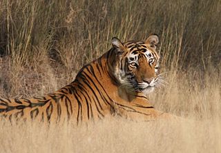
Reclining Tiger, Ranthambore National Park
Ranthambore National Park is known worldwide for its tiger population and is considered by both wilderness lovers and photographers as one of the best place in India to spot tigers. At one point, due to poaching and negligence, tigers became extinct at Sariska, but five tigers have been relocated there.
[24] Prominent among the wildlife sanctuaries are Mount Abu Sanctuary, Bhensrod Garh Sanctuary,
Darrah Sanctuary, Jaisamand Sanctuary,
Kumbhalgarh Wildlife Sanctuary, Jawahar Sagar sanctuary, and Sita Mata Wildlife Sanctuary.
Communication[edit]
Major ISP and Telecom companies are present in Jaipur including Airtel,
Data Infosys Limited, Reliance Limited, RAILTEL,
Software Technology Parks of India (STPI), Tata Telecom, Vodafone. Data Infosys was the first Internet Service Provider
[25](ISP) to bring internet in Rajasthan in April 1999 and OASIS was first private mobile telephone company, which was later taken over by
Airtel.
Government and politics[edit]
Administrative divisions[edit]
Economy[edit]
Rajasthan's economy is primarily agricultural and
pastoral. Wheat and
barley are cultivated over large areas, as are
pulses,
sugarcane, and
oilseeds. Cotton and tobacco are the state's cash crops. Rajasthan is among the largest producers of
edible oils in India and the second largest producer of
oilseeds. Rajasthan is also the biggest
wool-producing state in India and the main
opium producer and consumer. There are mainly two crop seasons. The water for irrigation comes from wells and tanks. The
Indira Gandhi Canal irrigates northwestern Rajasthan.

A marble quarry in Kishangarh Ajmer.
The main industries are mineral based, agriculture based, and
textile based. Rajasthan is the second largest producer of
polyester fibre in India. The
Pali and
Bhilwara District produces more cloth than
Bhiwandi, Maharashtra and the
bhilwara is the largest city in suitings production and export and Pali is largest city in cotton and polyster in blouse pieces and rubia production and export. Several prominent chemical and engineering companies are located in the city of
Kota, in southern Rajasthan. Rajasthan is pre-eminent in
quarrying and mining in India. The
Taj Mahal was built from the white marble which was mined from a town called
Makrana. The state is the second largest source of cement in India. It has rich salt deposits at
Sambhar, copper mines at
Khetri,
Jhunjhunu, and
zinc mines at Dariba, Zawar mines and Rampura Aghucha (opencast) near
Bhilwara. Dimensional stone mining is also undertaken in Rajasthan. Jodhpur
sandstone is mostly used in monuments, important buildings and residential buildings. This stone is termed as "chittar patthar". Jodhpur leads in
Handicraft and
Guar Gum industry. Rajasthan is also a part of the Mumbai-Delhi Industrial corridor is set to benefit economically. The State gets 39% of the DMIC, with major districts of Jaipur, Alwar, Kota and Bhilwara benefiting.
[26]
- Crude oil
Rajasthan is
[when?] earning Rs. 150 million (approx. US$2.5 million) per day as revenue from the crude oil sector. This earning is expected to reach
₹250 million per day in 2013 (which is an increase of
₹100 million or more than 66 percent). The government of India has given permission to extract 300,000 barrels of crude per day from Barmer region which is now 175,000 barrels per day. Once this limit is achieved Rajasthan will become a leader in Crude extraction in Country. Bombay High leads with a production of 250,000 barrels crude per day. Once the limit if 300,000 barrels per day is reached, the overall production of the country will increase by 15 percent. Cairn India is doing the work of exploration and extraction of crude oil in Rajasthan.
Transport[edit]
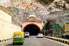
Road Tunnel in Jaipur Rajasthan
Rajasthan is connected by many national highways. Most renowned being
NH 8, which is India's first 4–8 lane highway.
[27] Rajasthan also has an inter-city surface transport system both in terms of railways and bus network. All chief cities are connected by air, rail and road.
- Air
There are three main airports at Rajasthan-
Jaipur International Airport,
Jodhpur Airport and
Udaipur Airport. These airports connect Rajasthan with the major cities of India such as Delhi and Mumbai. There are three other airports in Kota,
Jaisalmer and NAL(Bikaner) but are not open for commercial/civilian flights yet. One more airport at Kishangarh, Ajmer .i.e.
Kishangarh Airport is being constructed by the Airport Authority of India.
- Rail
Rajasthan is connected with the main cities of India by rail.
[28] Jaipur, Jodhpur, Kota, Bharatpur, Bikaner, Ajmer, Alwar, Abu Road and Udaipur are the principal railway stations in Rajasthan. Kota City is the only Electrified Section served by three Rajdhani Expresses and trains to all major cities of India. There is also an international railway, the
Thar Express from
Jodhpur (India) to
Karachi (Pakistan). However, this is not open to foreign nationals.
- Road
Demographics[edit]
Religion in State (2011)
[30]
Other religions (0.006%)

Children performing for Independence Day in village in
Alwar district, Rajasthan
Rajasthan has a mainly
Rajasthani population of approximately 68,621,012. Rajasthan's population is made up mainly of
Hindus, who account for 88.45% of the population.
Muslims make up 9.08%,
Sikhs 1.27% and
Jains 1% of the population.
[31] The state of Rajasthan is also populated by
Sindhis, who came to Rajasthan from
Sindh province (now in
Pakistan) during the India-Pakistan separation in 1947.
Culture[edit]
Rajasthan is culturally rich and has artistic and cultural traditions which reflect the ancient Indian way of life. There is rich and varied
folk culture from villages which are often depicted and is symbolic of the state. Highly cultivated classical music and dance with its own distinct style is part of the cultural tradition of Rajasthan. The music has songs that depict day-to-day relationships and chores, often focused around fetching water from wells or ponds.

Special Jodhpuri Mirchi vada
Rajasthani cooking was influenced by both the war-like lifestyles of its inhabitants and the availability of ingredients in this arid region. Food that could last for several days and could be eaten without heating was preferred. The scarcity of water and fresh green vegetables have all had their effect on the cooking. It is known for its snacks like
Bikaneri Bhujia. Other famous dishes include
bajre ki roti (millet bread) and
lashun ki chutney (hot garlic paste),
mawa kachori Mirchi Bada,
Pyaaj Kachori and
ghevar from Jodhpur,
Alwar ka Mawa(Milk Cake),
malpauas from Pushkar and rassgollas from Bikaner. Originating from the
Marwar region of the state is the concept
Marwari Bhojnalaya, or vegetarian restaurants, today found in many parts of India, which offer vegetarian food of the
Marwari people. 4
Dal-Bati-Churma is very popular in Rajasthan. The traditional way to serve it is to first coarsely mash the Baati then pour pure Ghee on top of it. It is served with the daal (lentils) and spicy garlic chutney. Also served with Besan (gram flour) ki kadi. It is commonly served at all festivities, including religious occasions, wedding ceremonies, and birthday parties in Rajasthan. "Dal-Baati-Churma", is a combination of three different food items — Daal (lentils), Baati and Churma (Sweet). It is a typical Rajasthani dish.

"Up-down" dolls are found in the roadside shops of
Jaisalmer.
The
Ghoomar dance from
Jodhpur Marwar and
Kalbeliya dance of
Jaisalmer have gained international recognition. Folk music is a large part of Rajasthani culture.
Kathputli,
Bhopa, Chang, Teratali, Ghindr, Kachchhighori, and
Tejaji are examples of traditional Rajasthani culture. Folk songs are commonly ballads which relate heroic deeds and love stories; and religious or devotional songs known as bhajans and banis which are often accompanied by musical instruments like
dholak,
sitar, and
sarangi are also sung.
Rajasthan is known for its traditional, colourful art. The block prints, tie and dye prints, Bagaru prints, Sanganer prints, and
Zari embroidery are major export products from Rajasthan. Handicraft items like wooden furniture and crafts, carpets, and blue pottery are commonly found here. Shopping reflects the colourful culture, Rajasthani clothes have a lot of mirror work and embroidery. A Rajasthani traditional dress for females comprises an ankle-length skirt and a short top, also known as a
lehenga or a
chaniya choli. A piece of cloth is used to cover the head, both for protection from heat and maintenance of modesty. Rajasthani dresses are usually designed in bright colours like blue, yellow and orange.

A traditional folk singer practising in front of Jodhpur fort.
The main religious festivals are
Deepawali,
Holi,
Gangaur,
Teej,
Gogaji,
Shri Devnarayan Jayanti,
Makar Sankranti and
Janmashtami, as the main religion is
Hinduism. Rajasthan's desert festival is held once a year during winter. Dressed in costumes, the people of the desert dance and sing ballads. There are fairs with snake charmers, puppeteers, acrobats and folk performers. Camels play a role in this festival.
Spirit possession has been documented in modern Rajasthan. Some of the spirits possessing Rajasthanis are seen as good and beneficial while others are seen as malevolent. The good spirits include murdered royalty, the underworld god
Bhaironji, and
Muslim saints. Bad spirits include perpetual debtors who die in debt, stillborn infants, deceased widows, and foreign tourists. The possessed individual is referred to as a
ghorala ("mount"). Possession, even if it is by a benign spirit, is regarded as undesirable, as it entails loss of self-control and violent emotional outbursts.
[32]
Education[edit]
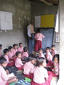
Children at a non-formal education centre
During recent years, Rajasthan has worked on the state of education. The state government has been making sustained efforts to improve the education standard.
In recent decades, the
literacy rate of Rajasthan has increased significantly. In 1991, the state's literacy rate was only 38.55% (54.99% male and 20.44% female). In 2001, the literacy rate increased to 60.41% (75.70% male and 43.85% female). This was the highest leap in the percentage of literacy recorded in India (the rise in female literacy being 23%).
[33] At the Census 2011, Rajasthan had a literacy rate of 67.06% (80.51% male and 52.66% female). Although Rajasthan's literacy rate is below the national average of 74.04% and although its female literacy rate is the lowest in the country, the state has been praised for its efforts and achievements in raising male and female literacy rates.
[34][35]
In Rajasthan,
Jodhpur and
Kota are two major educational hubs. Kota is known for its quality education in preparation of various competitive exams, coaching for medical and engineering exams while
Jodhpur is home to many higher educational institutions like IIT, AIIMS, National Law University, Sardar Patel Police University, National institute of Fashion Technology, MBM Engineering College etc. Kota is popularly referred to as, "coaching capital of India". Other major educational institutions are
Birla Institute of Technology and Science Pilani,
Malaviya National Institute of Technology Jaipur,
IIM Udaipur r and
LNMIIT. Rajasthan has nine universities and more than 250 colleges, 55,000 primary and 7,400 secondary schools. There are 41 engineering colleges with an annual enrolment of about 11,500 students. Apart from above there 41 Private universities like
Amity University Rajasthan,
Jaipur,
Manipal University Jaipur,
OPJS University, Churu,
Mody University of Technology and Science Lakshmangarh (Women's University, Sikar),
RNB Global University, Bikaner. The state has 23 polytechnic colleges and 152 Industrial Training Institutes (ITIs) that impart vocational training.
[36]
In rural areas of Rajasthan, the literacy rate is 76.16% for males and 45.8% for females. This has been debated across all the party level except BJP, when the governor of Rajasthan set a minimum educational qualification for the village panchayat elections.
[37][38][39]
Tourism[edit]

Blue City- a beautiful Aerial view
Rajasthan attracted 14 percent of total foreign visitors during 2009–2010 which is the fourth highest among Indian states. It is fourth also in Domestic tourist visitors.
[40] Tourism is a flourishing industry in Rajasthan. The palaces of Jaipur and Ajmer-Pushkar, the lakes of Udaipur, the desert forts of
Jodhpur,
Taragarh Fort (Star Fort) in Ajmer, and Bikaner and Jaisalmer rank among the most preferred destinations in India for many tourists both Indian and foreign. Tourism accounts for eight percent of the state's domestic product. Many old and neglected palaces and forts have been converted into heritage hotels. Tourism has increased employment in the hospitality sector.
Rajasthan is famous for its forts, carved temples, and decorated
havelis, which were built by Rajput kings in pre-Muslim era Rajasthan.
[citation needed] Rajasthan's Jaipur
Jantar Mantar,
Mehrangarh Fort and
Stepwell of
Jodhpur,
Dilwara Temples,
Chittorgarh Fort,
Lake Palace, miniature paintings in
Bundi, and numerous city palaces and haveli's are part of the architectural heritage of India.
Jaipur, the Pink City, is noted for the ancient houses made of a type of sandstone dominated by a pink hue. In Jodhpur, maximum houses are painted blue. At
Ajmer, there is white marble Bara-dari on the
Anasagar lake.
Jain Temples dot Rajasthan from north to south and east to west.
Dilwara Temples of
Mount Abu,
Ranakpur Temple dedicated to Lord Adinath in Pali District, Jain temples in the fort complexes of
Chittor,
Jaisalmer and
Kumbhalgarh,
Lodurva Jain temples,
Mirpur Jain Temple, Sarun Mata Temple
kotputli, Bhandasar and Karni Mata Temple of
Bikaner and
Mandore of
Jodhpur are some of the best examples.
See also[edit]


